The official name is the Independent State of Papua New Guinea. Located in the southwestern Pacific Ocean. The area is 462.84 thousand km2, the population is 5.3 million people. (2003). The official language is English. The capital is Port Moresby (325 thousand inhabitants, 2003). Public holiday – Independence Day September 16 (1975). The monetary unit is the kina.
Member of the UN (since 1975), IMF (since 1975), WTO (since 1994), APEC (since 1993, the only one of the developing countries of Oceania), the Pacific Islands Forum (formerly UTF, 1976).
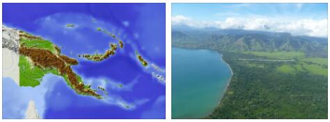
Papua New Guinea (Papua New Guinea), the largest of the developing states of Oceania, is located between 0° and 14°S latitude and 141° and 160° E longitude in the east of the island of New Guinea (the second largest island in the world), the Bismarck and Louisiade archipelagos, the D’Entrecasteaux group of islands and the northern part of the Solomon Islands (Bougainville and Buka Islands). Approximately 600 large and small (mostly) islands and atolls occupy approx. 15% of the country’s territory. From the border with Indonesia to the extreme atolls in the east – 2.1 thousand km. The total length of the coastline is 5152 km.
On land, Papua New Guinea borders Indonesia (820 km, New Guinea). To the north of Papua New Guinea are the Federated States of Micronesia, to the south – Australia, to the east – the Solomon Islands. It is washed by the Coral and Solomon Seas, the Bismarck Sea, and the Torres Strait separates APG from Australia.
The central mountains of New Guinea stretch across the entire island in the form of two parallel chains (the highest point is Mount Wilhelm, 4509 m). There are plains between the mountains. Plains on the coast and mountains in the central part are typical of most of the islands adjacent to New Guinea. On large islands, mountain peaks reach 2000-3000 m and occupy most of them. There are active volcanoes on the northern coast of New Guinea, New Britain and Bougainville. Geysers, mud craters, hot springs are common. Earthquakes are frequent, sometimes destructive (the country is located along the Pacific “Ring of Fire”). The total length of the river network is approx. 11 thousand km (the longest river is the Fly, 1200 km). The largest lake is Murray (647 km2). The swamp region in southwestern New Guinea is one of the largest in the world. The soils are extremely varied and fertile. The flora is rich. OK. 80% of the territory is occupied by forests: 13 types of tropical forest, 5 types of palm forests and swampy shrubs, 3 types of mangrove forests. Here is the largest species diversity of orchids in the world. The fauna is represented by marsupials – small tree kangaroos (wallabies) and marsupial badgers are common. There are flying dogs and echidnas, up to 70 species of snakes (mostly poisonous), approx. 650 species of birds (approx. 40 – paradise). In the rivers and coastal waters there are crocodiles, turtles, approx. 1400 species of fish. The fauna is represented by marsupials – small tree kangaroos (wallabies) and marsupial badgers are common. There are flying dogs and echidnas, up to 70 species of snakes (mostly poisonous), approx. 650 species of birds (approx. 40 – paradise). In the rivers and coastal waters there are crocodiles, turtles, approx. 1400 species of fish. The fauna is represented by marsupials – small tree kangaroos (wallabies) and marsupial badgers are common. There are flying dogs and echidnas, up to 70 species of snakes (mostly poisonous), approx. 650 species of birds (approx. 40 – paradise). In the rivers and coastal waters there are crocodiles, turtles, approx. 1400 species of fish.
Minerals: The country has rich natural resources. Of the explored minerals, the most important are gold, copper, silver, nickel, cobalt, oil (proven reserves – 345 million barrels) and natural gas (385 billion m3). The 200-mile economic zone (1.9 million km2) is rich in fish (15% of the world’s tuna resources). Forest and hydropower resources are very significant.
According to Bridgat, the climate is tropical and subtropical. All year round is hot and humid. Rainy season: December-March. The diversity of landscapes determines significant climatic differences. In the lowlands of New Guinea, the average daily temperature is +21-32°C. In the central mountainous regions there are significant fluctuations between day and night temperatures, frosts and even snow occur in the highlands. Average annual precipitation – St. 2000 mm, but vary greatly: in Port Moresby – approx. 1200 mm, and in the Kikori area – St. 5000 mm, although both are located on the coast of the same Gulf of Papua. There are also severe droughts, as well as devastating tsunami invasions.